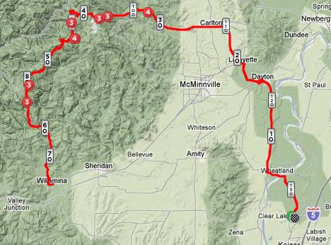
I needed a long ride with a lot of altitude gain to prepare myself for my last two races of the year. I also did not want to travel, so I devised a route where I could start from my home. Thus came into being the Mt Sheridian – Twice route.
The Mount Sheridian overlook is 2,800 feet above the Willamette Valley floor and is one of the longest climbs within riding distance. I have done the route a number of times, but never climbed up to the lookout twice in the same day. Oh, I found a challenge!
Time: 09:50:09
Elapsed Time: 11:19:06
Max Speed: 38.7 mph
Avg Speed: 13.6 mph
Bike: LeMond Victoire
I started from home at 6:30 am and headed north to the Wheatland Ferry. From there I took OR 221 north do Dayton, and then headed toward the small town of Lafayette and finally to Carlton. At Carlton, the climbing begins, but it is not too steep but it is long. I reached the overlook at 10:30.
The descent down to Willamina was tricky. There were somewhat large rocks on the roadway, large enough that if I hit one at speed, I could have gone down. So, I had to pay special attention and keep focused on the road in front of me.
Lunch in Willamina was quick – a bowl of corn chowder, and a meet and cheese plate as I am trying a gluten free diet.
During lunch, the sun really heated things up and it was quite hot as I rolled out of Willamina. I had two 24 oz bottles of ice cold sports drink, but this proved to be not enough. Five miles from the top, I ran out of water. I soon began to suffer; my mouth went dry and I felt my core temperature rising.
I was looking for someone to beg water and found some car enthusiasts at the lookout. I asked for water, but was told that one of the cars was overheating and they had already used most of what they had. However, a sweet young pre-teen girl gave me her last 4 ounces. Such kindness is rare and I thanked her.
I descended back toward Carlton and was surprised just how hot the valley floor was. I found a mini-market and consumed 48 ounces of fluids. Yes, I was thirsty!
From Carlton, I had only 30 miles left and they went fast due to a nice tailwind.
Average Speed: 8.8 mph
Average Heart rate: 127 bpm
Average Power: 165 w
Average Speed: 8.1 mph
Average Heart Rate: 139 bpm
Average Power: 154 w


